

|
![]() | videos| Site Map | Policy | Contact us |
| videos| Site Map | Policy | Contact us |
- Culture
- Music
- sports
- Politics
- Geography
- Tourism Potentials
- Environment
- Relief/climate
- Risks/disasters
- Activities
- Economy
- Transport
- Hotels
- Others
- Education
- Towns/provinces
- Languages
- Community
- Forums & discussions
- Videos About us
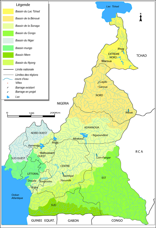
Also read about the drainage on this link >>>
CLIMATE
1. Temperatures
Cameroon falls within the intertropical zone and experiences yearly temperatures varying between 20 to 28 degrees Celsius. Temperatures generally increase from the south towards the north; this explains why there is a change from a humid and ever green south towards a hot and desert North. The temperature is also influenced by the proximity to the sea; the more you go hinterland, the hotter it becomes. Both situations are however waved off in several cases by altitude which influences the temperature; the higher you go, the colder it becomes as is the case with Yaounde which is higher (23.5degree Celsius) and Garoua (28 degree Celsius) which in within the Benue Plain.
2. Precipitation:
This is a phenomenon that is influenced by proximity to the sea and also the south to north extension of the country. Same too as temperature, it is also influenced by altitude. It is therefore for this reason that spatial variations exist through out the country for example, Douala receives 4,016 mm of rainfall annually, Yaounde 1,596mm, Lomie 1,654mm, Bamenda, 2,596mm, Garoua 1000mm and Kousseri in the Far North region receives only 630mm. Relative humidity varies in the same manner as rainfall based on the proximity to the coast.
Symptomatic of these combination of factors is the occurrence of four distinct seasons in the South and Central parts of Cameroon; these include: the long dry season at the beginning of the year, the long wet season from September to December, a short dry season in August and a short wet season between March and June. From the Adamawa to the Lake Chad which marks the Northern section of the country, there are two distinct seasons: a long dry season from November to April and a short wet season from May to October.
3. Air Masses
The movement of two major air masses across the country account for the two main seasons. These winds are referred to as the trade winds. They originate in the Northern hemisphere from the Azores anticyclone and in the south from the St. Helena anticyclone. The two air masses often converge over a low pressure centre called the Inter Tropical Convergence Zone (ITCZ) forming a front called the Intertropical front. The movement of this front depending on the dominant trade wind at the time conditions the type of season. For example when the south trade winds (also called the monsoon) blow more from the ocean pushing this front inland, this leads to the rainy season and conversely when the trades from the north also called the Harmattan push this front more down south, it leads to a general dry season through out the country.
The advent of the dry season in most parts of the country is often manifested by a total stop in the rainfall, harsh sun, blue skies and a generally dusty atmosphere. It also marks the end of several fluvial regimes. The arrival of the rainy season on the contrary is like the advent of new hope especially for farmers who get back into total activity. The landscape at this time is evergreen and nature blossoms out.
4. Climatic Regions in Cameroon
There are two broad climatic categories:
- The Equatorial climatic zone
- The Tropical climatic zone
- The Equatorial climate domain
The southern part of the country that extends from latitude 2 degrees to 6 degrees North is characterized by an Equatorial climate which is further subdivided into two categories:
- The Guinean type:
This extends from the coast at Kribi and covers the southern Plateau. It is marked by four seasons per year; two rainy and two dry seasons. Rainfall is abundant and ranges between 1500 to 2000mm. Temperatures are high and fairly constant measuring about 25 degrees Celsius on the average.
- The Cameroon type:
This is dominant in the southwestern coastal region and extends right up to the mouth of the river Nyong..
- The maritime Cameroon type:
Extends from the coastal region right up to the mouth of the River Nyong .This section encompasses the second rainiest part of the world, Debundscha, having rainfalls averages of 10,000mm per year. Humidity here is high and the influence of the mount Fako is ever present
- The mountain Cameroon type:
This prevails on the Western Highlands including places like Buea, Dschang, Bamenda, Kumbo etc. It extends northwards until it meets with the next climatic region, the tropical Sudan type.
- The Tropical climate domain
This is subdivided into the Humid Tropical and Sahel Climate. The Humid tropical climate type extends from about latitude 6 to 10 degrees. Rainfall here is about 1500 mm and there are two distinct seasons; the rainy and the dry season. The rainy season lasts for over seven months meanwhile the dry season lasts for between 3 to 4 months in some cases. The average temperatures here measures about 21 degree Celsius. The Sahel type extends from Benue Basin right up North. This region experiences shorter and shorter periods of rainfall as we move northwards. Temperatures equally become hotter and hotter as we progress towards the north. The tendency towards the Far North Region is to experience rainfalls of less than 900mm and rainy seasons as short as 4 months.
RELIEF
The central and western parts of Cameroon are dominated by high mountains and Plateaus respectively. The high western range has peaks which vary in elevation; 4100 m (mount Cameroon), 2250 (Mt. Manengouba), 2070m (Mt. Kupe), 2740 m (Mt Bamboutos), 2263 m Mt. Nkogam, 2119 m Mt. Oku and Mbot and the Mandara with certain peaks higher than 2000m. The Adamawa or Central High plateau has an altitude of between 1000 to 1500m. Both the western range and the Central high plateau are affected by volcanic and tectonic activities giving rise to faults, volcanic cones and volcanic lakes. These two sectors constitute the main watersheds of Cameroon’s drainage systems through the Sanage, the Benue, the Wouri, Moungo-Cross or Manyu and Donga-Mantung, towards the Atlantic Ocean.
The southern section of the country is dominated by a plateau (500 to 900m) which gently slopes to the east (Congo basin) but falls by steps to the Atlantic coast. Volcanic and tectonic activity affected this area too. While the far North is dominated by the lake Chad Basin, its southern fringe is strongly characterized by the River Benue Basin both of which present a monotonous relief. The narrow coastal zone is marked by unstable mangrove swamps, especially from the Wouri-Moung Basins to the Ndian-Akpa-Yafe Basins. The southern coastline and the ambas Bay region are rocky, cliffy and strewn with relic rocky islets, dating from the early volcanic period.
Besides the hills and valleys that mark the lanscape, there are a multitude of rivers.
To advertise on this site please contact us 
Copyright © 2009 www.cameroon-tour.com| All Rights Reserved
Authors Mphoweh jude Nzembayie and Futonge Nzemabyie Kisito