<<<,Home page
<<<Website Contents
Click to view each page as numbered
1 | 2 | 3|
4 | 5 | 6|
7 |8 | 9|
10 |11| 12
13| 14 | 15
16 | 17 | 18
19 | 20 | 21
22 | 23 | 24
25 | 26 | 27
28 | 29 | 30
31 | 32 | 33
34 | 35 | 36
37 | 38 |39|
40 | 41 | 42
43 | 44 | 45
46 | 47 | 48
49 | 50 | 51
52 | 53 | 54
Theme: THE DEGRADATION OF WETLANDS AND ITS SOCIO ECONOMIC AND ENVIRONMENTAL IMPLICATIONS IN NDOP CENTRAL SUBDIVISION, NORTH WEST PROVINCE CAMEROON
Page 56
l
Years |
||
From table 16, it can be seen that, given the same period of analysis in this study (.i.e. 39 years), farmlands would have attained up 112.7 km2. Based on the fact that wetlands originally occupied 315.54 km2 in 1963, it logical to believe that by 2040 when farmlands could have increased to 112.7 km2, there will be virtually no wetland area that has not been transformed to farmland or rice fields.
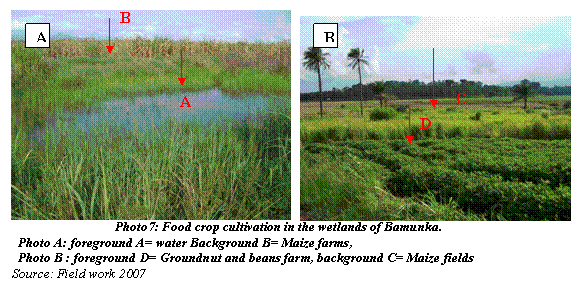
Photo 7 shows wetlands that have been transformed to farmlands and are usually cultivated with crops like maize; cocoyams, groundnuts, beans, vegetables, yams, potatoes, pumpkins etc. These crops are cultivated in a similarly alternate manner on the farms, which are never let to fallow; hence the regeneration of the natural values and functions of wetlands are almost impossible.
55 | 56 | 57 | 58 | 59 | 60| 61 | 62 | 63| 64 | 65 | 66| 67 | 68 | 69 | 70 | 71 |72 |73 | 74 | 75
76 | 77 | 78 | 79 | 80 | 81 | 82 | 83 | 84 | 85 | 86 |87 | 88 | 89 | 90 |91 | 92 | 93 | 94 | 95
<<<Back to table of contents || Go to next page>>>