Click to view each page as numbered

1 | 2 | 3|

4 | 5 | 6|

7 |8 | 9|

10 |11| 12

13| 14 | 15

16 | 17 | 18

19 | 20 | 21

22 | 23 | 24

25 | 26 | 27

28 | 29 | 30

31 | 32 | 33

34 | 35 | 36

37 | 38 |39|

40 | 41 | 42

43 | 44 | 45

46 | 47 | 48

49 | 50 | 51

52 | 53 | 54


Theme: THE DEGRADATION OF WETLANDS AND ITS SOCIO ECONOMIC AND ENVIRONMENTAL IMPLICATIONS IN NDOP CENTRAL SUBDIVISION, NORTH WEST PROVINCE CAMEROON

Page 74
in 1972. Here the River Nun is the main water course, accompanied by its tributaries.  Figure 15 b and photo 16 represent the situation after the dam was closed and an artificial lake came into existence.

74 
This lake extends over a very large area and has completely drowned the initial wetland vegetation cover that was found in this area. During the dry season (about January) when water is released from this reservoir, the original water course of the Nun is almost respected and the once existent flood plains appear as bare surfaces which are cultivated in some areas. By the rainy season, the dam is once more closed and huge quantities of water are accumulated. The accumulation of water in this dam has far reaching effects in the areas which are close to the lake (e.g. in some quarters of Bambalang like Mbashie, Mbakwong and Mbateh). Its effect also influences the water level of some streams which easily go over their banks and cross into other areas (e.g. the river Mukie in August after a heavy rainfall of about 15 mm). Some wetlands have also become too wet because of the effect of water which tends to stagnate (photo 17).

742

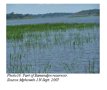
Photo 17: Wetland  in Bambalang that has become too marshy and uncultivable due to the Bamendjin reservoir
Source: Mphoweh J.N. Sept.  2007 

55 | 56 | 57 | 58 | 59 | 60| 61 | 62 | 63| 64 | 65 | 66| 67 | 68 | 69 | 70 | 71 |72 |73 | 74 | 75


76 | 77 | 78 | 79 | 80 | 81 | 82 | 83 | 84 | 85 | 86 |87 | 88 | 89 | 90 |91 | 92 | 93 | 94 | 95

<<<Back to table of contents || Go to next page>>>

Back to home page| Content page | contact us at |